Click here to go to the Golden Gate Bridge Menu
Click Here for our page with lists and maps of alternate locations for Golden Gate Bridge Parking when this lot is closed or full
Golden Gate Bridge Vista Point
and the Northeast Bridge Visitor Parking Lot
Highway 101 Northbound near Alexander Ave. off-ramp, Sausalito CA 94965 (See map below)
No office or phone
Golden Gate Bridge Vista Point Address for your GPS: The Golden Gate Bridge Vista Point has no address other than Highway 101 in Sausalito. On most car GPS systems it is listed as a POI (point of interest). Be sure to specify the Golden Gate Bridge Vista Point in Sausalito since user inputs to Google Maps have created name confusion between here and the Southeast Parking Lot in San Francisco.
Free parking (4 hour limit). Spaces often fill up during March-October and on weekends, so arrive early in the morning or late afternoon unless you are prepared to wait in line to get in. There are water fountains at Vista Point, but vending machines and the gift shop are at the Southeast Parking Lot.
Insiders Tip: During peak summer and holiday period visitor hours the lot at the Golden Gate Bridge Vista Point is often closed to passenger vehicles from 11:00 AM to 5:00 PM to avoid backing up traffic on the Bridge. When the lots are closed, only buses, shuttles, taxis, Uber and Lyft vehicles etc. are allowed to enter by the CHP to drop off and pick up passengers. The corresponding lot at the southern end of the Bridge is closed as well. Apart from the two well-known view parking areas, there are far more parking places on the southern end of the Golden Gate Bridge than on the north.
Here’s the catch: if you drive north across the Bridge from San Francisco to the Golden Gate Bridge Vista Point, realize you can’t park there and drive back across the Bridge southbound you’ll have to pay the toll even though you were only on the other side of the Bridge for less than a minute! One answer: during busy visitor seasons when the Vista Point parking lot is closed during the day, park at the southern end of the Bridge and then walk across the Bridge to Vista Point. We have all the details from past closures here.
Insiders Tip: The names of the view areas at either end of the Golden Gate Bridge can be confusing — so much so that if you Google “Golden Gate Bridge Vista Point” the user-edited Google Maps can show you the wrong end of the Bridge. The northern end, bordering Sausalito in Marin County, is called “Vista Point” and has a parking lot and bathrooms as well as great views. The southern end view area and south parking lot in San Francisco have just as nice a view from the opposite end of the Bridge (hence Google Maps users’ mis-labeling of the spot), but is referred to as the Southeast Parking Lot, even though this area includes Strauss Plaza and the Bridge’s Visitor Center.
How to Get To the Golden Gate Bridge Vista Point: Mass Transit
There is no direct bus service to the Golden Gate Bridge Vista Point, which seems illogical to those of us who don’t actually have to run transit services. Via Muni or Golden Gate Transit you still have to walk a ways after your bus ride.
From San Francisco via Muni: Muni Route 76 operates across the Golden Gate Bridge and stops at the entrance to the Conzelman Road parking lot by the Golden Gate Bridge. A pathway from the parking lot leads beneath the Bridge to Vista Point.
From San Francisco or Marin via Golden Gate Transit: From San Francisco: Route 30 and Route 92 stop at Alexander Ave. and Danes Drive (where the sign identifies the turnoff for Bunker Road), but you then have to cross the Sausalito Lateral (with high speed traffic) and walk about a quarter mile up the hill to reach Vista Point.
Insiders Tip: For me the best way to get to the Golden Gate Bridge Vista Point by bus from San Francisco is to take almost any northbound Marin Transit bus that crosses the Bridge (Routes 2, 4, 8, 10, 18, 24, 27, 30, 38, 44, 54, 56, 58, 70, 92, 97, and 101) and get off at the Golden Gate Bridge Toll Plaza. From there you can walk across the Bridge to Vista Point and experience both the Bridge and the viewing area. The same method works southbound from Marin. Yes, you’re walking over a mile to cross the Bridge, but it’s one of the most beautiful miles you’ll ever walk!
How to Get To the Golden Gate Bridge Vista Point: Driving
Driving via Northbound Highway 101: The Golden Gate Bridge Vista Point has its own exit from northbound Highway 101 at the northern end of the Golden Gate Bridge. Be sure to be in the far right hand lane by the time you reach the North Tower of the Bridge, since traffic often backs up from the Vista Point parking lot during nice weather, and any time on weekends or during the period from March through October.
ACCIDENT ALERT! Because of the parking lot backups mentioned above, traffic in the right lane northbound on Highway 101 near the north tower can go from 45 MPH to a dead stop very quickly and suddenly, and this is one of the spots in the Bay Area with the most fender benders. Assume that traffic in the right lane and even the center lane will stop suddenly as you approach the Bridge’s north tower so you’re ready to stop at any time.
Driving via Southbound Highway 101: You cannot reach Vista Point by car from Southbound Highway 101 without first crossing the Golden Gate Bridge, paying the toll, and then returning northbound to reach the Vista Point exit.
Insiders Tip: You can walk to the Golden Gate Bridge Vista Point, however, from the Conzelman Road parking lot… if you’re lucky enough to find a space there! A passageway leads from the Vista Point parking lot under the Golden Gate Bridge to the Conzelman Road parking lot. It is accessed via a stairway near the gate that connects the Bridge sidewalk and Vista Point.
Golden Gate Bridge Vista Point Views
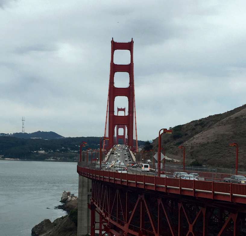
The classic “straight on” image of the Golden Gate Bridge at the top of the page is a photo I took at Vista Point. It’s no coincidence that they placed the viewing area at the perfect spot to take this photo!
Insiders Tip: The famous photos with the San Francisco skyline next to the Bridge are taken from the Vista Point on the Marin side. The famous shots with the Bridge and rocky cliffs are taken from the San Francisco side, often from the Southeast Parking Lot.
Bridge Access for Pedestrians and Bikes
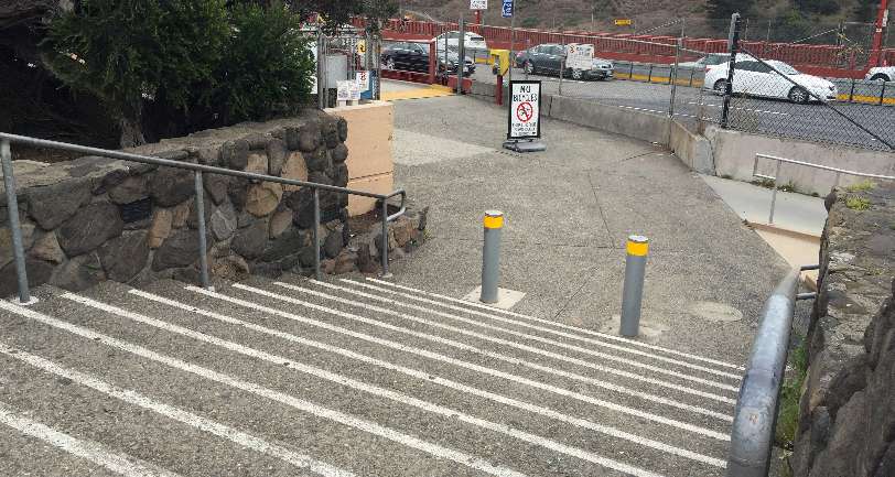
You can walk from the Vista Point parking lot to the east sidewalk of the Golden Gate Bridge. The gate and stairs down to the Bridge sidewalk (shown above) are located about 50 yards (40 meters) from where cars enter the Vista Point lot, and just to the right is a ramp for disabled and bike access.
Bikes are permitted on different sidewalks of the Golden Gate Bridge at different times of day — click on this link for more information. You may park at Vista Point and ride onto the east sidewalk directly, or access the west sidewalk (when open) via the passageway under the Bridge.
Access to Conzelman Road Parking Lot and Golden Gate Bridge Bridge West Sidewalk
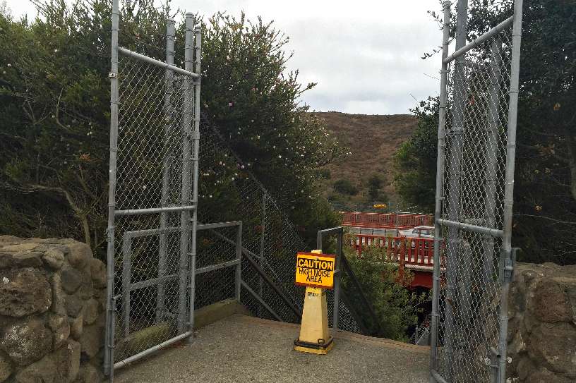
A stairway and passageway lead from the Golden Gate Bridge Vista Point sidewalk under the Golden Gate Bridge and up another set of stairs to the Conzelman Road Northwest Parking Lot and the Golden Gate Bridge West Sidewalk (where bikes have access on weekends and on late weekday afternoons). Ramps at the side of each stairway make it easier to walk your bike instead of carrying it. The entrance (shown in the photo above) is to the left of the sidewalk access steps.
The passageway under the Bridge is also a fascinating — though loud — place to visit.
Insiders Tip: It’s very loud inside the passageway under the Bridge. If a 16-wheeler goes across the expansion joint in the Bridge that’s over this spot it makes a very loud bang. If you’re sensitive to loud sounds you may want to cover your ears or use earplugs as you hurry under here.
Note: Google allows users to add labels to Google Maps, which introduces some errors (such as the mis-location of Vista Point noted above). The pier labeled “Vista Point” in the map below is actually the Fort Baker Pier, although we have to agree that it has great views!


